


Tigné Point
This location is also known as Dragut Point and Punta di Santa Maria.
In 1417 the militia had a guard post here called Punta di Santa Maria and was manned by 3 people.
App info: In our app you will find the location, address, opening hours and admission / entrance fee of this spot. If you use the app, you will find additional information and news about this spot on this page.
During the Great Siege of Malta in 1565, the Ottoman Admiral Dragut placed a number of cannons at this location to capture Fort Saint Elmo. Dragut, however, was killed by gunfire from the fort.
The Italian military engineer Antonio Maurizio Valperga planned on building a fortified city at this location in 1670 for a fortress similar to Fort Ricasoli. Philippe de Bourbon made a proposal in 1715 to build a gun. Both plans were not realized.
Then military engineer René Jacob de Tigné proposed building a large artillery battery in 1716.
Lembi Battery was built in 1757 to prevent an attacking enemy from bombing the north flank of Fort Manoel. The battery had a ditch around it, a triangular articulated platform and a small wooden house. The armament consisted of six 12-pounder guns. The Battery was demolished in the 19th century.
The designer was inspired by the Lunette d'Arçon, as well as the work of the military engineers of Marc René, Marquis de Montalembert and Antoine Étienne de Tousard.
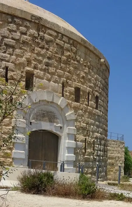
Grandmaster Emmanuel de Rohan-Polduc commissioned the engineer of the Order, Antoine Étienne de Tousard in 1792 to make a design for Fort Tigné.
The design was smaller than most of the Forts that were built at the time. It looked more like a big redoubt.
The fort was built between 1793 and 1795. The Fort was named Knight François René Jacob de Tigné (the nephew of the military engineer René Jacob de Tigné) in recognition of his long years of service and commitment to the Order. Tigné also contributed to the construction costs. Fort Tigné became the last major structure to be realized by the Order of St. John. The fort was equipped with six flint mortars, six shell firing mortars, twelve 24 pounder cannons, four 4 pounder cannons, six 12 pounder cannons and six 18 pounder cannons.
With the arrival of Fort Tigné, Lembi Battery became superfluous and was converted into a home.
During the French invasion in June 1798 the fort was used for the first time, unfortunately 13 cannons could not be used.
Under the leadership of the Bavarian Knight Joseph Maria von Rechberg, Fort Tigné was one of the few settlements offering strong resistance to the invasion.
On June 10, 1798, the French tried to get hold of the fort, but failed. The fort fired its cannons, and the Navy ships of the Order of St. John counterattacked. The French were prevented from entering the port of Marsamxett.
On June 11, the French bombed the fort from the sea and from the land. Ridder Rechberg was able to obtain more ammunition.
By June 12, the French had conquered Valletta, Floriana, and Fort Manoel, and the fort was still fired at from two sides. The Maltese militia left the fort. Ridder Rechberg was left behind with 80 men.
When the ammunition ran out at the end of the day and the fort was damaged, Rechberg and his soldiers tried to escape. The fort was conquered.
In 1799 the fortification of the fort was reduced to 21 cannons.
The fort was taken over by the British in September 1800 and the damage repaired. A garrison was stationed in 1805. In 1815 the fort was armed with 30 guns and the area was expanded with, among other things, a barracks.
In 1860 the British recognized the power of the small, flanked fort and it was used as a prototype for other polygonal forts. The design of military engineer René Jacob de Tigné can be considered revolutionary because it was one of the oldest polygonal forts in the world.
The parapet was demolished, and reinforcement modified.
In the 1870s and 1875s a part of the parapet was demolished. RML 9 inch 12 ton guns were placed there and significant changes took place.
In 1880 it was proposed that the fort was replaced with a larger fort and in 1888 it was proposed that the ramparts be reduced.
In 1890, changes were made to gun positions and parts of the structure were converted into accommodations.
The fort was damaged during an air raid in World War II.
After the departure of the British in 1979, the Fort fell into disrepair.
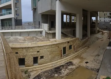
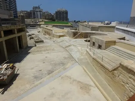
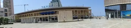
The area has been redeveloped since 2002. The barracks gave way to The Point Shopping Mall. A number of arches along the square are still showing restored parts of the barracks.
The fort was restored and integrated into the shopping centre.
Address and street / location can be found on our map, click on Guide in the menu bar and you will get a map with markers. | |
Book: Buy tickets for place of interest. sights, hop on hop off buses, exhibitions, safari, etc or book and tour. | |
Latest news and original website of the attraction / spot / advent | |
Additional information