


The Mystery of the Car Ruts in Malta
Malta is home to one of Europe’s most intriguing archaeological enigmas: the countless parallel grooves carved into the bedrock across the islands of Malta and Gozo, commonly known as Car Ruts.
The Facts at a Glance
Number: An estimated 150 sets of parallel tracks.
Depth: Ranging from a few centimeters to as deep as 60 centimeters.
Track Width: Between 10 and 50 centimeters.
Distance Between Tracks: Remarkably consistent, around 140 cm, with slight variations.
Shape: Mostly U-shaped, with some V-shaped.
Length: Some run for just a few meters, others stretch for several kilometers.
Surface: Both bumpy and smooth sections exist.
Route: Tracks run in straight lines, but also in curves or turns.
Endpoints: Many end abruptly—sometimes at the edge of cliffs, in the sea, in two cases at quarries, and about thirty at or near ancient temples.
Age: Estimated by some to be as old as five million years, but most theories place them before the last Ice Age—between 2.6 million and 12,000 years ago.
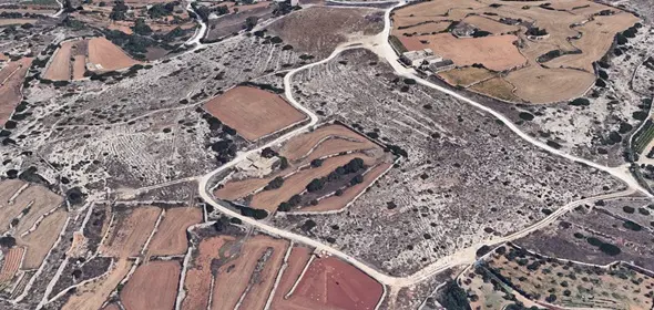
Main Concentrations: Around Rabat, Siggiewi, and especially at the site known as “Clapham Junction” (Misrah Ghar il-Kbir), named after the chaotic railway station in London.
Similar Grooves Worldwide: Found in countries including Germany, France, Portugal, Spain, Italy, Switzerland, Greece, Azerbaijan, the Azores, Turkey, India, Brazil, Mexico, and Bolivia. However, Malta has by far the highest concentration.
Depth: Ranging from a few centimeters to as deep as 60 centimeters.
Track Width: Between 10 and 50 centimeters.
Distance Between Tracks: Remarkably consistent, around 140 cm, with slight variations.
Shape: Mostly U-shaped, with some V-shaped.
Length: Some run for just a few meters, others stretch for several kilometers.
Surface: Both bumpy and smooth sections exist.
Route: Tracks run in straight lines, but also in curves or turns.
Endpoints: Many end abruptly—sometimes at the edge of cliffs, in the sea, in two cases at quarries, and about thirty at or near ancient temples.
Age: Estimated by some to be as old as five million years, but most theories place them before the last Ice Age—between 2.6 million and 12,000 years ago.
Main Concentrations: Around Rabat, Siggiewi, and especially at the site known as “Clapham Junction” (Misrah Ghar il-Kbir), named after the chaotic railway station in London.
Similar Grooves Worldwide: Found in countries including Germany, France, Portugal, Spain, Italy, Switzerland, Greece, Azerbaijan, the Azores, Turkey, India, Brazil, Mexico, and Bolivia. However, Malta has by far the highest concentration.
Theories and Speculations
Many different ideas have been proposed to explain the origin and purpose of these mysterious grooves:
Transport Theory: A widely accepted idea is that the ruts were made by vehicles transporting heavy loads, such as stones. At the Mnajdra and Ħaġar Qim visitors’ centers, it is suggested that stone blocks were moved on cylindrical stone rollers rather than wheels. However, no such rollers or wheels have ever been found.
Ley Lines and Energy Paths: Some researchers and spiritual theorists believe the ruts align with so-called ley lines—hypothetical energy paths that are also associated with Malta's megalithic temples. There is no scientific proof that such energy lines exist, let alone that they influenced the placement of the ruts.
Maltese archaeologist Anthony Bonanno thinks the tracks were made by the Phoenicians (7th century BC).
Alien Intervention: As with many ancient mysteries, some suggest that extraterrestrials were involved in creating or using the ruts. This idea remains purely speculative, lacking any evidence.
Agricultural Use: A more down-to-earth theory suggests that the ruts were part of an ancient irrigation or farming system. Perhaps the grooves were filled with soil or water to help retain moisture and improve crop yields. Still, this doesn’t explain why the ruts are always in pairs and often extremely deep.
Despite these theories, none are conclusively supported by scientific evidence. The questions remain: Who made these tracks? When? And why?
A Personal Theory
I would also like to share my own theory—not scientifically proven, but meant to keep the discussion alive:
I believe the Maltese temples are not just 5,000 years old but at least 12,000 years. The density of both quarries and temples suggests intense activity. The fact that some tracks disappear into the sea may indicate they were made at a time when the Mediterranean Sea was partially or fully dry—something that could only have occurred during extreme low sea levels in the Ice Age.
That period was significantly wetter and rainier. Malta consists of two types of limestone, which lose up to 80% of their load-bearing capacity when saturated with water. If heavily loaded carts (possibly sled-like vehicles) moved across such terrain, deep grooves could easily have formed.
Furthermore, I am convinced that ancient civilizations possessed more knowledge than we often assume. It's unlikely that humans suddenly went from crafting simple stone tools to building complex temples overnight. There must have been gradual development—or perhaps lost knowledge.
And finally, if the ruts lead into the sea, might there once have been temples under the waves that are now lost to time?
The tracks of Cart ruts can be found in various places on the island of Malta at St Paul's Bay, Naxxar, Busewdien, Bidnija, San Gwann and the most beautiful tracks can be found in Siġġiewi near the Dingli cliffs and on Gozo on the Ta 'Ċenċ- plateau, Sannat.
In Conclusion
The Car Ruts of Malta remain a captivating mystery that invites curiosity and debate. Whether they were born of practical needs, spiritual beliefs, lost technologies, or something else entirely—we don't yet know. But we should continue to ask questions, to explore, and to keep the conversation alive.
Someday, we may discover the answer.
Address and street / location can be found on our map, click on Guide in the menu bar and you will get a map with markers. The tracks of Cart ruts can be found in various places on the island of Malta at St Paul's Bay, Naxxar, Busewdien, Bidnija, San Gwann and the most beautiful tracks can be found in Siġġiewi near the Dingli cliffs and on Gozo on the Ta 'Ċenċ- plateau, Sannat. |
Opening hours
The locations are public, it is advised not to walk here in the dark.